Peter's Bypass Quiz
The bypass is a quintessential British road feature, and the idea of a bypass conjures up images of roadhouses, retail parks and industrial estates.
This quiz contains 24 OS map extracts, all taken from current on-line mapping, showing A-road bypasses. All you need to do is identify them. Send your answers to me by e-mail.
They are all at the same scale, north is always at the top, and most identifying text has been removed. Some are easy, some are much harder, so e-mail me with the ones you know.
I have now added the answers for all the map extracts.
Thank you to everyone who took part.
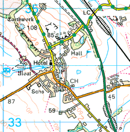
Question 1
The north-east facing, tidal shore should help narrow this one down. Whisky lovers might find this a tranquil place.
The A9 at Tain in Northern Scotland. The Glenmorangie Distillery (supposedly meaning "glen of tranquillity") is situated here.
Question 2
Two 2-digit A-roads, with different first digits, multiplex on this bypass.
The A49 and A51 at Tarporley in Cheshire.
Question 3
A 1930s bypass of a small, attractive village. The new bridge carrying the primary route running to the north was added at a much later date. The caravan site suggests we are in a tourist area - and the contours show some steep hills.
This is the A6 at Ashford-in-the-Water, just north of Bakewell in Derbyshire.
Question 4
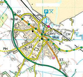
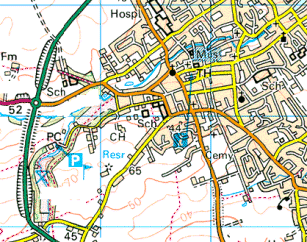
The park and ride site suggests we are near to a major city, although I must admit I was surprised to see one here. The tidal estuary running to the east should help locate it. What map feature is conspicuous by its absence?
The A90 at Ellon in North-East Scotland - the nearby city is Aberdeen, but it is 17 miles away!
Question 5
This is a single-digit A-road, together with its rail equivalent.
The A1 and the East Coast Main Line at Belford, Northumberland.
Question 6
The wide, tidal estuary running to the north-west should help narrow it down. The bypass appears to cross via a rather impressive bridge.
The A39 at Wadebridge, Cornwall.
Question 7
I have never been here, but the bypass seems rather over-specified for the size of the village and the importance of the road. The spot heights should help with the location, but it is further north than you might initially think.
The A165 at Leven, east of Beverley in the East Riding of Yorkshire.
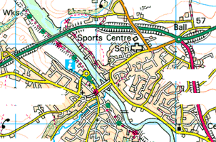
Question 8
Although this looks as though it might be an attractive market town, complete with a set of almshouses, it is actually in a fairly grim and run-down industrial area.
Yorkshire again, this time the A628 at Hemsworth between Barnsley and Pontefract. This is one of the most depressing post-industrial landscapes in Britain.
Question 9
The county boundary should help here. Water towers tend to be built in the drier parts of the country. Note the mapping anomaly with the B-road which doesn't link up with the A-road.
The A143 at Harleston on the Norfolk/Suffolk border.
Question 10
The boundary and the parallel railway and canal crossing a steep valley should make this one of the easier ones. The road viaduct is quite impressive too.
The A5 at Chirk in North-East Wales.
Question 11
Although near to one of the UK's most picturesque areas, this small town is very much off the tourist trail. Melvyn Bragg might feel at home here.
The A596 at Wigton in North Cumbria, Melvyn Bragg's birthplace.
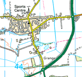
Question 12
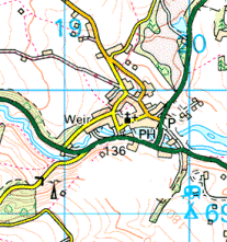
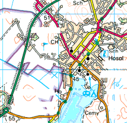
A village-cum-small town at an important road junction, on a south-flowing, tidal river. The bypass, built in the 1960s, runs unusually close to the village centre.
The A40 at St Clears in Carmarthenshire. Several people have pointed out that the bypass was in fact built in the 1970s. I recall walking round St Clears on a Sunday afternoon in the 1960s and finding it very quiet, but perhaps there just wasn't much traffic back then.
Question 13
This bypasses a pair of villages sharing the same name - one is Great, the other Little. The important railway junction has a different name entirely. The canal was an equally important trunk route before the railway age.
The A51 at Great and Little Haywood in Staffordshire, running parallel with the Trent & Mersey Canal the West Coast Main Line (including Colwich Junction where the main line for Manchester diverges).
Question 14
A very unusual layout, where the bypass carries a red A-road, while a primary route continues to pass through the village centre. The red road has 2 digits, the primary route 3.
The A29 and A272 at Billingshurst in Sussex.
Question 15
A long, straight single-carriageway bypass giving a wide berth to a small market town set amidst broad acres in rich agricultural country.
The A19 at Easingwold in the Vale of York. The county of Yorkshire is often referred to as "the broad acres".
Question 16
The spot heights and the windmill give a clear indication of which part of the country we are in here. The road in question has often been condemned as boring on SABRE - one of its few interesting features is just to the east.
The A17 at Long Sutton in Lincolnshire. Sutton Bridge swing bridge is to the east.
Question 17
The spot heights and contours suggest hilly country, perhaps on the Celtic fringe. The primary route is more important than it once was, and originally carried a now defunct road number.
The A470, formerly A492, at Llanidloes in Mid-Wales.
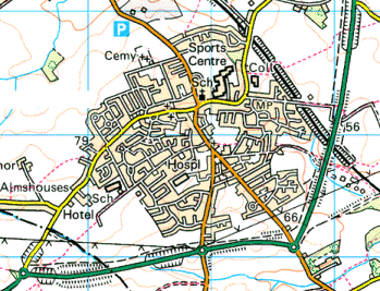
Question 18
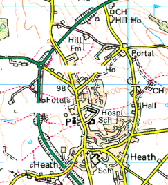
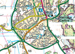
A unique and perverse layout, where one of the two main roads runs right into the town centre, then turns left at a crossroads to use part of the bypass. The hilly National Trust land to the east might make completing the bypass difficult. A photo of the narrow lane leading to the church in this attractive market town has adorned many a calendar and chocolate box.
The A417, A438 and A449 at Ledbury, Herefordshire.
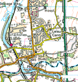
Question 19
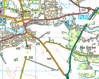
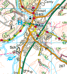
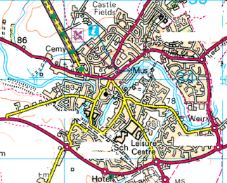
A small town standing beside a fair-sized lake. The map has the same distinguishing feature as Question 4. The road is well-used by lorries heading for a ferry port.
The A75 at Castle Douglas, South-West Scotland.
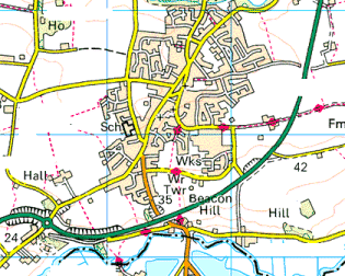
Question 20
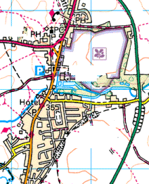
This bypasses a particularly long village, with a magnificent church overlooking the village green shown on the map. The National Trust property shares the name of the village.
The A134 at Long Melford in Suffolk.
Question 21
A fair-sized market town in an agricultural area in one of the less-visited parts of the country. The bypass carries a 2-digit A-road, and meets three different 3-digit A-roads.
The A16 at Louth in Lincolnshire.
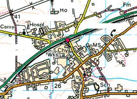
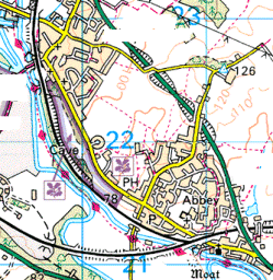
Question 22
Another water tower here, but the best clue is the railway. Where might you find an open passenger station on a "light rapid transit or narrow gauge railway" that, from the terrain, clearly isn't in Wales?
The A140 at Aylsham in Norfolk. The 15" gauge Bure Valley Railway is one of the few narrow-gauge passenger railways in England.
Question 23
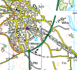
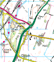
The land falling steeply to the north-west, and the science park, might help locate this. The stained glass in the village church might give you the impression of being in Wonderland.
The A56 at Daresbury, near Runcorn in Cheshire. Lewis Carroll's father was the vicar of the village church, which now has windows commemorating Alice in Wonderland.
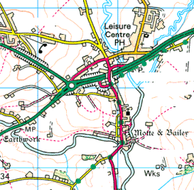
Question 24
The road running east-west along the bypass is shown as primary in most atlases. The National Trust own the estate to the north-west, but the house is a well-known public school.
The A421 at Buckingham in the county of the same name. Stowe School lies to the north-west.